Physical Address
304 North Cardinal St.
Dorchester Center, MA 02124
Physical Address
304 North Cardinal St.
Dorchester Center, MA 02124
This is AI generated summarization, which may have errors. For context, always refer to the full article.
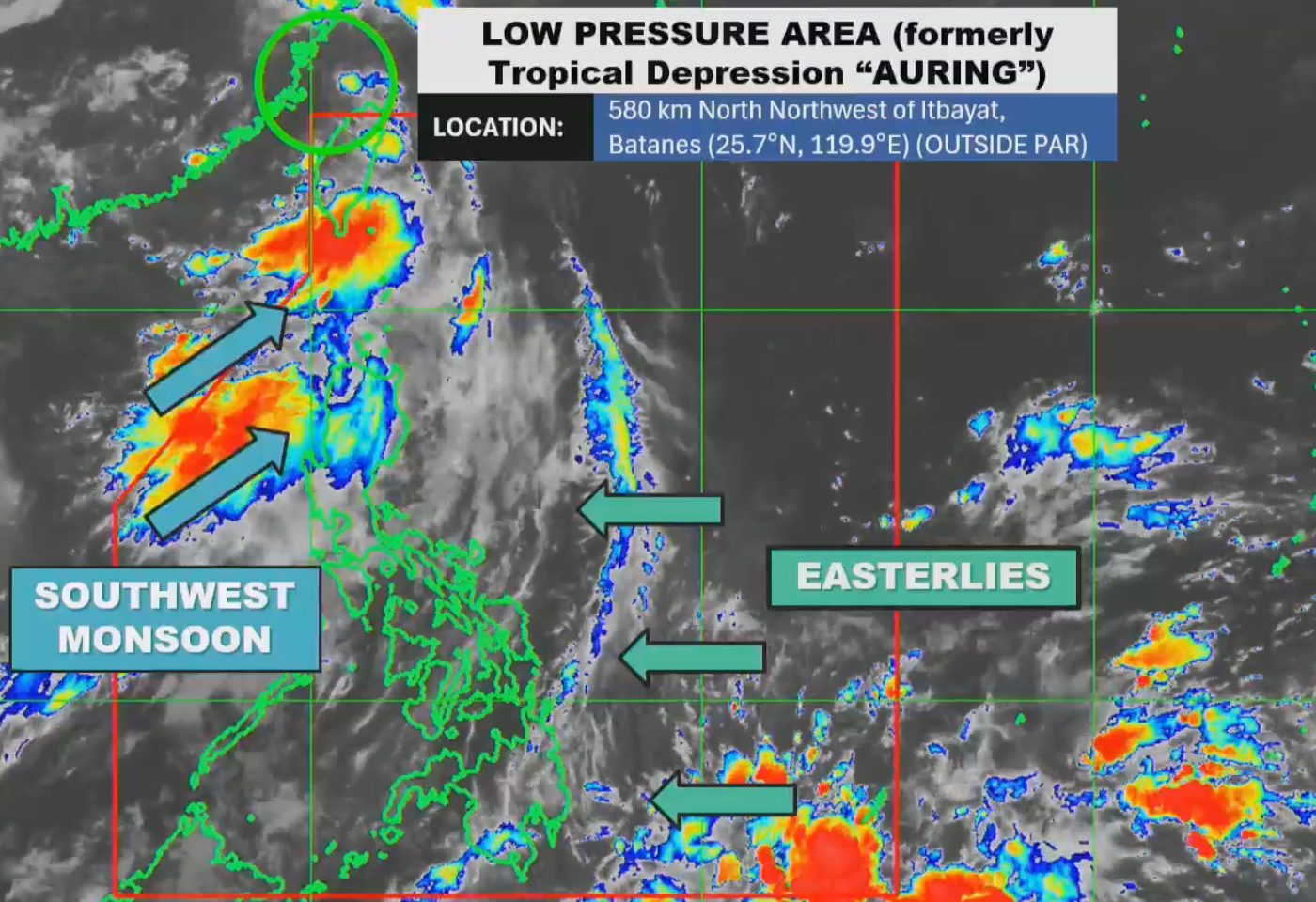
The trough or extension of the low pressure area that used to be Tropical Depression Auring may still cause scattered rain and thunderstorms in Batanes on Friday, June 13
MANILA, Philippines – Tropical Depression Auring weakened into a low pressure area (LPA) and left the Philippine Area of Responsibility (PAR) at 2 am on Friday, June 13, around six hours after it developed.
By 4 am, the LPA that used to be Auring was already 580 kilometers north northwest of Itbayat, Batanes. It is moving northwest outside PAR at a relatively fast 40 kilometers per hour.
The Philippine Atmospheric, Geophysical, and Astronomical Services Administration (PAGASA) explained that Auring weakened due to the “frictional effects” of its landfall in Taiwan on Thursday evening, June 12. Taiwan is within PAR.
With the downgrade, the LPA “is now less likely to bring significant heavy rainfall over Northern Luzon,” added PAGASA. But its trough or extension may still cause scattered rain and thunderstorms in Batanes on Friday.
During its brief stay inside PAR, Auring brought moderate to heavy rain to Batanes and Cagayan.
Tropical cyclone wind signals were not raised due to Auring. But strong to near-gale gusts are expected in Batanes and Babuyan Islands on Friday because of the southwest monsoon or habagat.
Also on Friday, the Ilocos Region and Babuyan Islands will have scattered rain and thunderstorms due to the southwest monsoon.
Scattered rain and thunderstorms will hit Surigao del Sur and Davao Oriental as well, but due to the easterlies or warm winds coming from the Pacific Ocean. Isolated rain showers or thunderstorms are expected in the rest of the Philippines, including Metro Manila, still as a result of the easterlies.

As for coastal waters, the seaboards of the Ilocos Region, Zambales, Batanes, and Babuyan Islands have moderate to rough seas on Friday, with waves 2.5 to 3 meters high. PAGASA advised small vessels not to venture out to sea.
Meanwhile, the western seaboard of Bataan has up to moderate seas, with waves up to 2.5 meters high. Small vessels should take precautionary measures or avoid sailing, if possible.
Auring was the Philippines’ first tropical cyclone for 2025.
PAGASA earlier said one or two tropical cyclones are expected to form within or enter PAR in June. For the next six months, or from June to November, there could be 11 to 19 tropical cyclones.
The start of the rainy season was declared on June 2, while the southwest monsoon’s onset was announced on May 30. – Rappler.com