Physical Address
304 North Cardinal St.
Dorchester Center, MA 02124
Physical Address
304 North Cardinal St.
Dorchester Center, MA 02124
This is AI generated summarization, which may have errors. For context, always refer to the full article.
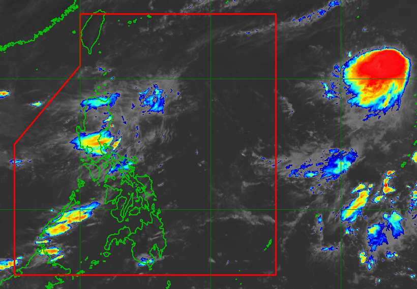
PAGASA says Podul’s maximum sustained winds increased to 95 km/h on Saturday morning, August 9
MANILA, Philippines – Podul intensified from a tropical storm into a severe tropical storm outside the Philippine Area of Responsibility (PAR) on Saturday morning, August 9.
In an advisory issued at 11 am on Saturday, the Philippine Atmospheric, Geophysical, and Astronomical Services Administration (PAGASA) said Podul’s maximum sustained winds increased from 85 kilometers per hour to 95 km/h. Its gustiness is now up to 115 km/h from the previous 105 km/h.
Podul could strengthen further into a typhoon on Sunday, August 10, before its projected entry into PAR late Sunday evening or early Monday morning, August 11.
Once it enters PAR, it would be given the local name Gorio.
As of 10 am on Saturday, the severe tropical storm was located 2,155 kilometers east of extreme Northern Luzon, slowly moving west northwest.
Podul is expected to maintain its west northwest movement on Saturday. Afterwards, it may head west on Sunday and Monday, then west northwest again or northwest starting Tuesday, August 12.
Given this possible track, where Podul would stay far from Philippine landmass, the tropical cyclone “is less likely to directly affect the weather and sea conditions” in the country in the next five days.

PAGASA reiterated, however, that there is “large uncertainty” in Podul’s projected track and intensity Monday onwards.
“Any northward or southward shift in the track forecast will significantly change the intensity forecast,” the weather bureau said. “All are advised to continue monitoring subsequent tropical cyclone advisories for Podul.”
PAGASA expects two or three tropical cyclones to form within or enter PAR in August. The first one for the month, Tropical Depression Fabian, left PAR at 1 am on Saturday, less than a day after it developed.
On Saturday, the southwest monsoon or habagat continues to affect the country.
Mimaropa, Bicol, Quezon, and Western Visayas are seeing scattered rain and thunderstorms, while the rest of the country could have isolated rain showers or thunderstorms due to the southwest monsoon. – Rappler.com