Physical Address
304 North Cardinal St.
Dorchester Center, MA 02124
Physical Address
304 North Cardinal St.
Dorchester Center, MA 02124

This is AI generated summarization, which may have errors. For context, always refer to the full article.
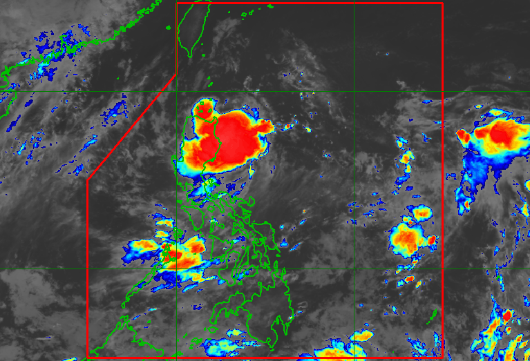
The low pressure area is 380 kilometers northeast of Daet, Camarines Norte, or 390 kilometers east of Casiguran, Aurora, at 3 am on Thursday, August 7
MANILA, Philippines – The low pressure area (LPA) inside the Philippine Area of Responsibility (PAR) is affecting nearly the entire Luzon, the weather bureau warned the public before dawn on Thursday, August 7.
The LPA was last spotted 380 kilometers northeast of Daet, Camarines Norte, or 390 kilometers east of Casiguran, Aurora, at 3 am on Thursday.
Scattered to widespread rain and thunderstorms are expected in Cagayan Valley, the Cordillera Administrative Region, and Aurora during the day.
The LPA will also trigger scattered rain and thunderstorms in Metro Manila, the Ilocos Region, the rest of Central Luzon, Calabarzon, Bicol, Occidental Mindoro, Oriental Mindoro, Marinduque, Romblon, and Northern Samar.
Flash floods and landslides are possible.
The Philippine Atmospheric, Geophysical, and Astronomical Services Administration (PAGASA) said the LPA still has a low chance of developing into a tropical depression within 24 hours.
But it is projected to cross the landmass of Luzon around Thursday evening to Friday, August 8, according to PAGASA Weather Specialist Chenel Dominguez.
Dominguez added that after crossing land, the LPA might become a tropical depression over the West Philippine Sea.
PAGASA previously estimated that two or three tropical cyclones could develop within or enter PAR in August. The next three local tropical cyclone names are Fabian, Gorio, and Huaning.
Aside from the LPA off Luzon, another LPA is also being monitored, located outside PAR.
The second LPA was 2,815 kilometers east of Northern Luzon as of 3 am on Thursday. While it remains far and has no effect on the country, eventual entry into PAR is not being ruled out.
In addition, the second LPA now has a “medium” chance of developing into a tropical depression in the next 24 hours, upgraded from “low.”
Meanwhile, the southwest monsoon or habagat is affecting Palawan, the Visayas, and Mindanao on Thursday.
Due to the southwest monsoon, scattered rain and thunderstorms will hit Palawan, much of the Visayas, the Zamboanga Peninsula, Northern Mindanao, Caraga, and the Bangsamoro Autonomous Region in Muslim Mindanao, while isolated rain showers or thunderstorms are likely in the rest of Mindanao.
Those areas should also watch out for possible flash floods and landslides. – Rappler.com